Friday, March 30, 2012

Xeriscaping and Native Plants: A Work in Progress

Ownership of property, our homesite is at best only a temporary state. Our possession time is limited, because our lifetimes are finite! Someone else will eventually take over stewardship of this land. But we first discovered the property online for sale in November 2005 and the following March purchased it via Cathy Bagley and Boulder Mountain Realty, Inc. The land was formerly a partial within the area's Utah School Land Trust acreage. It had been recently offered for private purchase. A buyer / developer subdivided the lands into 10 and 20 acre or larger lots, created roadways and brought in phone and electrical lines via underground cables.
Tiered beds of varied sagebrush and other native plants
We live on the slope of Boulder Mountain, UT (7,500 ft. elevation). Our house and property are in the pinyon and juniper woodland zone. That means that our surrounding landscape is dominated by pinyon pine (Pinus edulis) and species of juniper (Juniperus osteosperma). We also have a few Ponderosa Pines and Douglas fir. A few miles away, we can visit Bristlecone Pines.

Our average yearly precipitation (rain and snowfall) is 6-7 inches. The arid, high altitude climate is characterized by cold winters (Dec-Jan night time temps can drop into the minus teens, but our usual sunny days see temps raise into the mid-twenties or higher) and a few hot, summer days mid to late July highs rise above ninety degrees combined with cool, comfortable nights). But weather in our Intermountain West region is variable. We sometimes get a 'January thaw' that provides a welcome relief or have a summer season with few hot days. We very seldom need or use air conditioning.

Young and old Ponderosa pine (Pinus ponderosa).
Traces of an old wagon road can still be faintly seen winding up the valley wash and ending on the southwest corner of our lot. Locals tell us that Teasdale bench residents once used that route to gather firewood up here. There is also an old stock trail coming down from above; its overturned white rock pathway can be traced to upper grassland areas to intersect with the Coleman Donkey Reservoir road. Seasonal hunters, a few hikers and horsemen, and ranchers were probably infrequent visitors to our location. Today we can also find traces of earlier visitors. In the sandy slope in front of our house, each new rain often brings a few more stone tool flakes to the surface.
Indian rice grass was already growing here; added the desert holly.
So at the time we purchased the land, not many other intrusions had recently impacted here. There were only two possible home sites on the near 10 acres; one in the extreme southwestern corner - - a road ending that we call 'the turnaround.' The other on a small knoll overlook that was adjacent to a 50-60 ft. rock and gravel talus slope down to Cottonwood wash. The wash comes near the turnaround and bisects the southeast corner of our lot to head on down the valley to benchland below (Back of the Coombs' pasture). Our ground is rocky and rolling; there are not many level spots. Other than the road cuts and exposed slickrock inclines, it is covered with trees growing in the rock and gravel base. Dig anywhere and you will hit rocks, dig those rocks out and you will find more rocks underneath. Dig a little further and you will hit sandstone. Sometimes you can 'worry' some of that out with a pick or digging bar, but there's not much dirt! And we don't have a use for a lawnmower.

Before we built the house, we had Lavar Wells (Besides drilling water wells, Lavar has other well known skills) and crew drill a water well that can be used sparingly for landscape plants, but we recognize that water is an expensive and limited resource. After building, we turned attention to the landscape surrounding the high desert house and considered the available water. Two terms became prominent in our thinking and plans - - xeriscaping and native plantsXeriscaping refers to using methods in landscape design to minimize use of water.
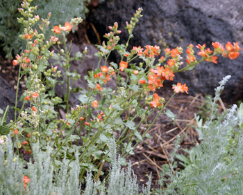
Munro's Globe Mallow (Sphaeralcea munroana);
some locals call it stinkweed.
Useful Online Resources:
Anderson, Berniece (Rev. May 1996). Desert Plants of Utah. Utah State University Extension.

Kuhns, Michael (Rev. May 2008). Conifers of Utah. Utah State University Extension.


Plants from Wild Utah


Weeds and Wildflowers (Utah)
One of ten Blue Spruce (Picea pungens) that we planted as near twigs.
Favorite Native Plant Sources:
Bob Emrich
Lives in the Grover area; sells nursery plants at the Farmers' Market in Torrey (4 p.m. Saturdays during the summer at the Robber's Roost Bookstore)
Purchased a few trees plus several shrubs and native flowers / plants. Lost one tree over the winter (lack of water), a Bristlecone Pine (I will replace it when Bob has another seedling ready). Also have some pentstemon flowers and few other plants (Winterfat, moss plant, etc.) - all doing fine.
Good prices and Bob is an excellent source of information too.

Fremont River Conservation District

HC 61
Box 30
Fremont, UT 84773
Phone: (435) 681-0303
Before building, we cleared most of the dead limbs and trees off the property. This fuels reduction was done to lessen the threat of a forest fire, and because our lot is adjacent to the National Forest, it was a required process (Assisted by an in-kind federal grant, administrated by Utah Forestry, Fire and State Lands / UT Dept of Natural Resources). Once the dead limbs and trees were removed, we had a large area away from the house with very little cover. Each spring, our local paper (The Insider) has an article about tree stock that can be purchased via the Fremont River Conservation District. Not all are native plants; however we ordered and received 10 Blue Spruce that are native to our area. Very affordable price but the stock arrives as very small plants. With a drip line installed and regular watering through the dry months, all of them have grown well. Watch for the article in the paper; offered once a year.

Great Basin Natives

http://www.greatbasinnatives.com/
Have not visited the nursery or purchased anything from there; have talked with them on phone. Plan to stop by sometime when in the area.
75 West 300 South
Holden, UT 84636

High Country Gardens in Santa Fe, NM

http://www.highcountrygardens.com/
Ordered several orange Globe Mallow wildflowers online; lost some of them over the winter, rest are thriving and spreading.

Rugged Country Plants
53671 West Crockett Road
Milton-Freewater, OR 97862 
Ordered and received several Indian Paintbrush wildflowers (Difficult to grow; it's been a few years and waiting to see results this spring - know that a few made it). Also purchased several sage plants and they are doing fine (Big Sagebrush, Mountain Big Sagebrush, White Sagebrush, Black Sagebrush, Fringed Sagebrush).
Good prices; watch the timing of placing orders; some plants are only available in early spring or in the fall.

Wildland Nursery
370 E 600 North
Joseph, UT 84739
We have purchased 3 ponderosa pines (7-8 ft tall) and a few desert holly plants. All are thriving.
Janet (owner) requests that people call ahead first. Phone: 435-527-1234  She is also an excellent source of information about native plants and landscaping.

Tuesday, November 3, 2009

The Wayne Umpire

Have always been interested in vintage photographs. They capture a historical scene and transmit information about a time and place (Visual literacy). With permission from Peter and Kathy Hafen, I share a photograph from their blogsite: Mt. Pleasant Pioneer Relic Home and Blacksmith Shop.


The photograph from 'Carrie's Photo Album' was taken on July 9th, 1931 and is described as a Lions event (Mt. Pleasant Lions Club outing to Torrey, UT?). In those bygone days, the roads here were gravel - - Hwy 24 from Loa to Torrey was paved in 1941 (Snow; 1953, 76).

James H. Knipmeyer's memoir "Tales from Torrey and of Capitol Reef" briefly tells of the history of The Umpire Store:
"Originally built as a frame building in 1910 and then converted to a rock structure about 1912 or 1913, it was operated as a store by Ephraim P. Pectol. At that time it was known as the Wayne Umpire Store. Why the name 'Umpire,' no one any longer seems to know." (Part III - 1969 Home)

The building today is part of Austin's Chuckwagon General Store.

Snow, Anne (1953). Rainbow Views: A History of Wayne County. Art City Publishing Company.

Wednesday, June 10, 2009

Chimney Rock Loop Hike

April 2009
3 and 1/2 miles round trip
Steep elevation gain - 900 ft.
Wear a hat and carry water, very little shade
Completed in 1 hour 50 minutes - made several stops, moderate pace.

A cool, windy day with snow flurries coming in over Boulder Mountain and a significant amount of snowfall predicted for the following day; Annette and I took an afternoon break and headed out to explore a hiking trail in Capitol Reef National Park. We have driven past the Chimney Rock pinnacle numerous times and have wanted to hike the loop trail. The trail head parking area is a short distance off highway 24 (northside of hwy) and near the west border of the park; about 8 1/2 miles from Torrey (20 minutes from our house; Boulder Mtn., near Teasdale). Chimney Rock is near Panorama Point, the Goosenecks of Sulphur Creek, and Sunset Point - - all those are located close together and off the opposite side, south of route 24. Just to be sure that everyone understands, The Chimney Rock Trail does not actually take you up or out onto Chimney Rock! It does take you up nearby and above Chimney Rock.

It was almost three oclock in the afternoon. The sky was overcast; winds were bringing in cooler air, dropping temperatures from the low fifties. Still, it was comfortable hiking weather when wearing a light jacket and hat. Even in this early Spring season, we carried plenty of water (about 1-quart each). There is a bathroom at the small parking lot; the parking area can only hold maybe 8 to 10 vehicles. Today we found the lot empty. Recommend being prepared for any unexpected weather changes, but we have found Fall, Winter, and Spring to be the best hiking seasons in this area.

The first portion of the trail led us over the sand and gravel path to sweep out, curving to the northeast for about 1/4 mile before beginning a steep winding ascent. After climbing about 300 feet on the switchback path, we reached the plateau trail junction point for our loop path. We took the right fork (heading southeast) to continue our strenuous climb, knowing that our loop section would wrap around in a counterclockwise fashion to bring us back to this trail junction. Along the way we stopped at a few of the viewpoints to catch our breath and look back west towards Torrey and across to Boulder Mountain. We noticed the clouds and snow sometimes almost completely obscured our view of the mountain.

Chimney Rock can be seen and photographed from the highway, the parking lot and the lower trail section, but some of the best views are just above the loop junction. Here about one-half hour into our hike, we can look down on the prominent spire that has eroded out off the side of the mesa. Chimney Rock stands 300 feet above the road, a pillar of red to chocolate brown Moenkopi sandstone layers topped by a light-colored Shinarump cap. The sandstone boulder cap is uranium rich and protects the softer levels of MoenKopi shale below it by slowing down the effects of erosion.

Our counterclockwise path continued up and southeastward and soon lost sight of the Chimney as we made a steep climb over Mummy Cliff and onto the mesa top summit (6,634 feet elevation). We began to sense the allure of this popular park trail. It has the physical challenge of the steep, strenuous climb that is relatively short, plus allows close study of some of the rock strata common to this region (pdf document from the National Park Service), and provides numerous panoramic views that are stunning. Continuing across the mesa top (the larger Meeks Mesa is above and to the north), we neared completion of the first-third of our hike and sensed that there was a lot more to come. We also knew that we had already put the biggest elevation climb behind us. The rest should be a 'piece of cake' (we found that it was).

Our walking path led us across the mesa top to an observation spot on the southeast corner. Here we took in the excellent views along the Waterpocket Fold, Hway 24 heading toward Fruita and further into Capitol Reef National Park. After a brief pause, we followed the trail as it dropped off the backside of the mesa and switched back to follow a plateau ridge on north eastward.

The trail soon brought us to another fantastic viewpoint near the eastern limits of our hike. From this location near the half-way point, we can look out to the layered sandstone cliffs and observe several more of Capitol Reef's geologic features. Here we looked out on the colorful talus slopes with their muted shades of purple, grey and brown that are characteristic of the Chinle Formation. Above are the massive dark red vertical cliffs of the Wingate Formation that tower upwards for hundreds of feet in the sky. Our jaunt next took us north through a badlands stretch and the upper plateau drainage to then make a brief climb around a few eroded Moenkopi spires. Here we made another brief stop at another great viewpoint, then trekked around the corner to shortly intersect a trail junction for the Spring Canyon cross country route (Spring Canyon itself begins about a mile to the East). At this point, we know that we have walked about 2 1/4 miles from the trail head / parking lot.


Now we are turned to the west and continuing through Chimney Rock Canyon for the return leg of our trip. We were walking over Chinle cobbles. Along the way, we noted the sparkle of numerous cracked gypsum crystals found in the terrain. At some locations on the trail, you can see parallel bands of gypsum embedded in Moenkopi shale layers. We also saw petrified wood chunks scattered near the trail. The path continued on to drop down even lower in a sandy wash and there in the banks, we saw several large trunk sections of petrified wood. The path through Chimney Rock Canyon soon brought us back to our first trailhead junction. From there, we made the steep descent down the Moenkopi shale incline and returned to the parking lot.

This was a perfect hike for us. Great exercise, beautiful views, and varied formations like those towering Wingate cliffs found in many locations throughout Capitol Reef National Park. We will do this again; there is always a new viewpoint to examine, something you missed before, plants and wildlife to see. Next time, we should do the loop section in the opposite direction - - some people recommend this as the best approach. This is one of the most popular trails in the park and today we had it all to ourselves.

Note - The temperature continued to slowly drop. The following day, we received the largest snowfall of the year (winter season) at our home on Boulder Mountain. We measured 10 - 12 inches of the white stuff; much of it melted off our road by Sunday afternoon and we could travel out. We were snowed in for a brief spell, but it's likely that this trail was dry. It's usually ten degrees warmer in Capitol Reef than at our house.

Catch you next time, somewhere on down the trail . . .

Monday, April 27, 2009

Living Rural and Loving It!

Annette and I are recent 'moved in' residents of Southern Utah (April 2008). It's a beautiful place; we are surrounded by gorgeous landscapes. We have mountains, towering red rock cliffs, sandstone hoodoos and fins, arches, natural bridges, slickrock, mountain lakes, the Fremont River, bristlecone pines, 'quakey' aspen groves, lower desert areas, slot canyons, waterfalls and much, much more.

We live in Wayne County with about 26 hundred other full-time residents. We see mule deer, elk, wild turkey, bighorn sheep, marmots, and have noticed the track of a cougar around the front yard a time or two. There are also bears and bobcats in the neighborhood. That's about as rural as one can get in the lower 48! Well except for Loving County, Texas with their population of 67 people. Loving County has 677 square miles; Wayne County has 2,460. Still Loving County has the lowest population density in the entire United States. Population density there is close to zero per square mile while here in Wayne Co. it's 1 person per square mile (2nd lowest in Utah; neighboring Garfield County's is .9).

The main reason that Wayne County has so few residents is that only a little over three percent of the land is privately owned; all the rest is state or federal government lands - - BLM, national forest, or state and national parks. The lands are all part of the colorful Colorado Plateau geographical province. A good part of Capitol Reef National Park and a portion of Canyonlands National Park are inside Wayne County. Originating on Fish Lake Mountain to the north, the Fremont River flows south into the County and then curves east to join the Dirty Devil, which is a tributary of the Green River. The Green River forms the County's eastern border. Wayne County also has a big portion of Fishlake National Forest.

The County seat in Wayne Co. is Loa with about 525 people living there. The town's name is derived from the Hawaiian mountain Mauna Loa; the lofty title means high, large and powerful. The other towns within the County are Bicknell, Fremont, Lyman, Teasdale, Torrey, Caineville, and Hanksville. Caineville is more of a community these days; but does have a motel and the Mesa Farm Market (produce / bakery). Other than Loa and the few people that live in Caineville, town sizes here range in population from about 200 to around 350 people.

One thing that holds these rural communities together is that everyone helps out - not just in one way but in varied ways. It's not uncommon to find people serving their communities in different roles. There are volunteer fire-persons, emergency medical technicians, and search and rescue squad members, etc. People show up to help out on community 'clean up' days, stop to help someone with a vehicle broke-down on the road, contribute to worthy local causes - - leaders help coordinate events, and the rest help out wherever we can.

Did I mention that there is not one traffic light in the County? Two major highways serve the area; Route 24 and Highway 12 - - the latter is one of the most scenic drives in the U.S. Spring through Fall, motorcycle tour groups frequent the roads along with the usual contingent of bikers, cars and RVs.

It's a gorgeous land between other enticing lands. Within a few hours drive from our Boulder Mountain home, we can explore the Henry Mountains (last explored peaks in continental U.S.) and the vast expanses of the San Rafael Swell, Glen Canyon Recreation Area, Lake Powell, and southern Utah's sweep of other national parks and monuments - - Arches, Canyonlands, Grand Staircase Escalante, Bryce Canyon, Cedar Breaks, and Zion. It's no small wonder that neighbors in nearby states in the Southwest often visit southern Utah for mountain biking, camping, hiking, hunting, fishing and even skiing at Brian Head Resort near Cedar City.

The Navajo called this area the "land of the sleeping rainbow." Early residents of the area, Ephraim Pectol and Joseph Hickman, promoted it as the "Wayne Wonderland." This land of mountains, forests, sandstone, and desert contains an ancient foundation of igneous and metamorphic rocks that later were covered by sediments and shifted by the sliding of tectonic plates and then for eons was mainly shaped by large-scale water erosion to create this wonderland that is relatively undiscovered by the rest of the country. It is an area that is popular with international travelers, and you are as likely to encounter friendly European and Japanese tourists as flatlanders from back east.
For full-time residents of southern Utah, this is also a 'land between' - - between here and any number of other memorable locations. This is a part of the Grand Circle tour. By applying the phrase a land between, I mean that we are surrounded by almost unending opportunities for exploration and travel. On the northern edge of the state, we have both the soaring Watsatch and Uinta Mountain ranges.

Consider a day's drive in almost any direction - - that can take one to Estes Park and the Rocky Mountain National Park in Colorado. Or you can be visiting the Four Corners region, Mesa Verde National Park, and the Teleuride and Durango, CO regions or be in Taos and Santa Fe or visit the Chaco Culture National Historical Park in New Mexico. To the south, you can easily reach Monument Valley , Canyon de Chelly National Monument or the Grand Canyon National Park, all three in Arizona. It's less than a day southwest to reach Las Vegas, NV or Death Valley National Park. To the west is the Great Basin National Park. And in about the same 8 or 9 hrs., one can reach Jackson, Wyoming and nearby Grand Teton and Yellowstone national parks.

So . . . back to living here on Boulder Mountain. What makes that so unique and appealing?
One: It has to be the closeness to our natural environment; living and being outdoors, and for us - - hiking, camping, and backroading.
Two: The unique, rich community with people who ranch, work in the forest or the parks, builders, construction workers, and craftsmen. Persons who work in the businesses, restaurants, motels and lodges, bed & breakfasts along with residents who are photographers, writers, painters, potters, musicians, philosophers, and other artisans and craftspersons - truly an eclectic mix.
Three: The seasonal mix of quiet, natural sounds of Winter mixed with the bustle of the tourist seasons.
Four: Attending local events that include the Entrada Institute, Apple Days in Torrey (July 4th), the Bicknell International Film Festival, Torrey Music Festival, Women's Redrock Music Festival, and the Wayne County Fair (August).
Five: Opportunities to see, photograph and experience wildlife and nature.
Six: Buying local produce and products that include beef and mutton / lamb as well as bread and fresh garden vegetables.
Seven: The state and national parks, the national forest, and BLM public lands - - all that space and it's easy to find your own quiet spots.
Eight: Beautiful high mountain landscapes that encompass subalpine (pinyon & juniper) and alpine forests (Ponderosa pine, Douglas Fir, and Quaking Aspens), lakes (more than seventy on Boulder Mountain alone) and streams.
Nine: Beautiful sandstone strata and forms plus the nearby lower desert regions. It's usually ten degrees warmer about twenty minutes away from the house.
Ten: Capitol Reef National Park has the largest orchards in the park system; that means fresh, delicious, pick-them-yourself fruit including cherries, apricots, apples, peaches, and pears. There is nothing finer!

Beautiful country, great neighbors, good people make for an outstanding community. We are lucky to call it home.

Listen to John Mellencamp's song 'Small Town' at YouTube.

Saturday, February 21, 2009

What is it about mountains and flatlanders?

I was born and lived a few early years in north central Arkansas - - the hilly part. I briefly went to school there (small town of Leslie). My family then moved to a farm near another small town, Findlay, in east central Illinois. I grew up, graduated from a nearby state university, and spent half my life in those Midwest flatlands. But I've always loved mountains, forests, and rivers.

Annette was born in Ames, Iowa and has family roots in rural west Iowa farm country. Growing up in her early years, her father was first in the Air Force followed by employment with General Electric. The family moved around the country to assignments in Long Beach, St. George, Winslow, and Biloxi followed by Louisville and Schenectady before returning to Iowa. But frequent vacation trips to Estes Park and Rocky Mountain National Park also imprinted her with a love for mountain landscapes - - that and she was / is a big fan of John Denver.


Annette and I have visited West Virginia a number of times. We have rafted down the New River, peered down the foggy canyon gorge at the bridge, hiked and biked a few mountain trails, viewed awesome waterfalls, and driven some backroads in that unique and beautiful state. For decades, the land and water have been threatened. This song parody points to today's continuing problems facing the coal-laden mountain area:


A recent court decision poses increased threats to the terrain, streams, and people living in the Appalachian Mountains by expanding the number of permits for mountaintop removal coal mining. Mountaintop removal is pretty much just that - - tear the top of the mountain by first bulldozing away 500 to 1,000 feet of overburden to get to the coal seams. Then the mountain is blasted down with explosives to allow enormous dragline excavating equipment to move the rubble aside and remove the coal. The pulverized remains of the mountain ends up filling streams and valleys. Mountaintop removal mining is only used for about 5 percent of coal mining today, but the area impacted is huge. In the Appalachians over 400 peaks have been leveled so far. By next year the EPA predicts that this coal mining method will have destroyed about 1.4 million acres - an area larger than the state of Delaware. Representatives Frank Palone (NJ), John Yarmuth (KY), and Dave Reichert (WA) recently re-introduced a Clean Water Protection Act, the HR1320 CWPA bill. HR1310 reverses a 2002 Bush Administration decision that defined the toxic rubble left from Mountaintop Removal Coal Mining as 'fill material' that could then be dumped into valleys that are the headwaters of Appalachian riverways. In the
video below, Ashley Judd speaks out against mountaintop mining and makes a fervent plea for help.


Here in our adopted home in the Rocky Mountain West, there are similar extractive threats to the landscapes, natural resources, and way of life. As a 'moved-in" resident, I try to maintain a grounded viewpoint recognizing that just by purchasing and building our home here - - we too made a significant impact on the land. We cleared areas and altered the landscape for our driveway and the homesite. We had a water well drilled and installed a septic system, and underground electrical, phone, and water lines. That's invasive!

We strive to be good stewards and good neighbors. We have cut out dead trees, trimmed branches, and removed undergrowth in order to reduce the fire fuels on our high desert land. We sought and were given lots of help from the Utah Division of Forestry, Fire and State Lands; qualified for an in-kind grant for wildfire hazard reduction.
Advocates for the environment (like ourselves to some degree) need to examine our positions, meet and listen to our neighbors, and try to gain a 'bigger picture' when dealing with local land use issues.

I recommend a book written by friend and neighbor, Stephen Trimble:
Bargaining for Eden: The Fight for the Last Open Spaces in America (2008). There is a brief and important excerpt at High Country News: Credo: The People's West (June 23, 2008).